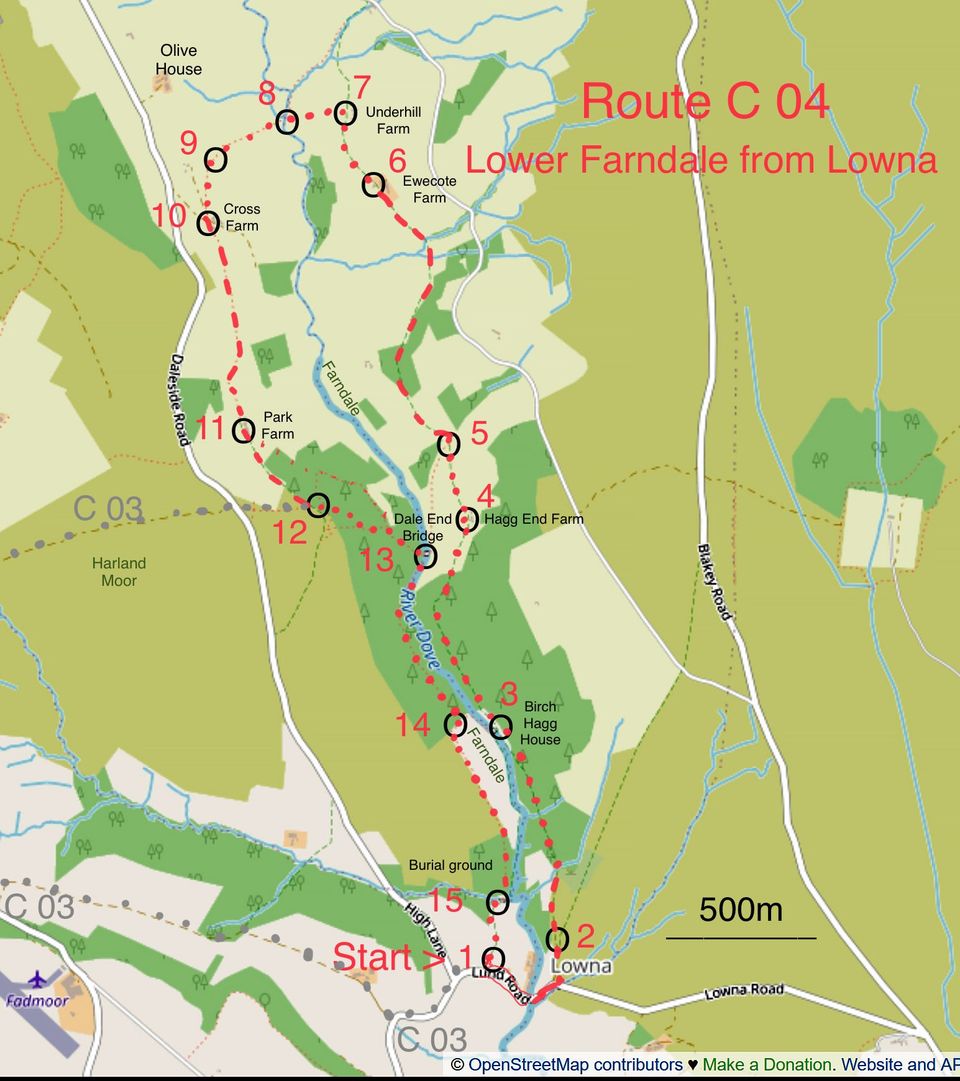
C 04 Lower Farndale: Map and directions
Route C 04: Lower Farndale, from Lowna
This 5-mile circular walk sets out from Lowna with a gentle climb through woodland to a path on the east side of Farndale, with views up the valley on a clear day. The route then crosses the River Dove and climbs to a path on the west side of Farndale and later descends to a path near the river, back to Lowna. This is NOT the famous “Daffodil Walk” but there are daffodils in flower near to the path at the end of March. There are fields with sheep and there may be mud.
Start from a small car park – from Hutton-le-Hole, keep left on leaving the village and turn left near the top of a hill towards Gillamoor; descend to cross a bridge, pass Lowna Farm and turn right (OS Explorer map OL26 North York Moors western area, ref SE686910), the entrance is not signed.
Walk directions
1. From the car parking place (map reference 686910), walk down the road, cross Lowna Bridge and a cattle grid then go straight on where the road bends right. Continue up the track, passing a gate, to a signed track to Low Mill on the left. [Total 500 metres]
2. (688911) Take the track to the left and through a gate into a wood. Follow the path through the wood to a gate beside Birch Hagg House. [800m]
3. (685918) Go through the gate, where a sign points to Low Mill, and follow the footpath upwards through trees and gradually away from the river. Through a gate out of the wood, cross a field (keeping to the left of a wall) to farm buildings. [800m]
4. (685926) Keep to the left of Hagg End Farm, passing through a gateway in a stone wall, continuing slightly downhill and across fields through gateways finally converging with a stone wall at a gate. [300m]
5. (684929) Go through the gate and join a mud/stone track that fords a small stream, then goes through a gate and slightly uphill, crossing a wider track and continuing through a gate (where woodland on the left ends). Follow the track through gates as it becomes a bit narrower to Ewecote Farm. [1100m]
6. (681938) After passing the farm, keep straight on along a narrow path (do not follow the vehicle track to the right). Continue to the next farm, Underhill Farm. [300m]
7. (680940) Opposite a gate into the farm, turn left through a gate onto a signed path downhill across a field to a gate. Through the gate, cross a boggy, sedgy area to a footbridge. [250m]
8. (678941) Cross the bridge and follow the path slightly left over a boardwalk and up steps to a stile. Over the stile and up a grass path to another stile, then over this and across a sedgy field to another stile. [total 300m]
9. (675939) Go over the stile and slightly left on a boardwalk over a stream then across a small field to a waymarked gate below a house. Follow the waymark diagonally across the field to Cross Farm. [250m]
10. (675937) Go through the gate towards the back of the buildings and turn sharp right then left onto the higher level path beside a stone wall. Follow this path through a gate and through bracken with the wall to the left, later through a gateway and slightly left downhill to Park Farm. [800m]
11. (677928) Enter the concrete yard through a gate and leave by a grass and compacted soil track through another gate (an alternative path to the left at this point is temporarily closed). Continue along the track for 400m, passing through another gate to the point where a forest track joins from the left. [500m]
12. (680926) Turn sharp left onto the track to the left and look for a narrow waymarked path on the right. Follow a narrow, winding footpath through woodland to a stile onto a wider path near a wooden signpost. Go over the stile and continue downhill on the waymarked narrow path through bracken. Continue for about 350 metres to a wooden signpost and take the path to the left, downhill, very steep towards the end, to Dale End footbridge. [700m]
13. (683925) Do not cross the bridge but turn right along the river bank and continue to follow the path for 700 metres to a path junction near to Birch Hagg House on the opposite side of the river. [700m]
14. (685919) Turn right (uphill) at the junction and in 100 metres turn left onto a signed path (that later passes a Quaker burial ground). Continue round a bend to the right leading to a footbridge over a tributary stream. [700m]
15. (686913) Turn left across the bridge and continue to the car park. [250m]


